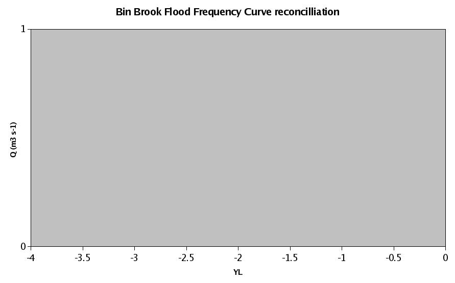
| 30014 (Pointon Lode @ Pointon) |
1 |
0.3 |
21 |
0.39 |
0.23 |
0.26 |
0.91 |
| 36010 (Bumpstead Brook @ Broad Green) |
2 |
0.37 |
27 |
0.38 |
0.15 |
0.09 |
0.67 |
| 36009 (Brett @ Cockfield) |
3 |
0.41 |
25 |
0.28 |
-0.07 |
0.03 |
0.67 |
| 25010 (Baydale Beck @ Mowden Bridge) |
4 |
0.49 |
17 |
0.25 |
0.05 |
0.12 |
0.6 |
| 33030 (Clipstone Brook @ Clipstone) |
5 |
0.58 |
13 |
0.34 |
-0.08 |
0.1 |
1.67 |
| 31025 (Gwash South Arm @ Manton) |
6 |
0.59 |
15 |
0.25 |
0.17 |
0.19 |
0.92 |
| 38026 (Pincey Brook @ Sheering Hall) |
7 |
0.66 |
20 |
0.3 |
-0.09 |
0.04 |
0.89 |
| 35003 (Alde @ Farnham) |
8 |
0.7 |
26 |
0.26 |
-0.1 |
0.01 |
0.96 |
| 37012 (Colne @ Poolstreet) |
9 |
0.78 |
22 |
0.39 |
0.17 |
0.17 |
0.63 |
| 37016 (Pant @ Copford Hall) |
10 |
0.78 |
21 |
0.38 |
0.33 |
0.31 |
0.93 |
| 33809 (Bury Brook @ Bury Weir) |
11 |
0.79 |
15 |
0.35 |
-0.03 |
0.11 |
1.25 |
| 36004 (Chad Brook @ Long Melford) |
12 |
0.82 |
27 |
0.34 |
0.3 |
0.37 |
1.13 |
| 31023 (West Glen @ Easton Wood) |
13 |
0.85 |
22 |
0.4 |
0.4 |
0.31 |
1.3 |
| 36012 (Stour @ Kedington) |
14 |
0.86 |
18 |
0.31 |
0.26 |
0.33 |
0.76 |
| 20002 (West Peffer Burn @ Luffness) |
15 |
0.87 |
26 |
0.32 |
-0.02 |
0.11 |
0.49 |
| 32003 (Harpers Brook @ Old Mill Bridge) |
16 |
0.9 |
25 |
0.3 |
-0.02 |
0 |
0.87 |
| 37013 (Sandon Brook @ Sandon Bridge) |
17 |
0.92 |
30 |
0.26 |
0.04 |
0.12 |
0.35 |
| 36002 (Glem @ Glemsford) |
18 |
0.93 |
31 |
0.23 |
0.18 |
0.33 |
1.29 |
| 35004 (Ore @ Beversham Bridge) |
19 |
0.94 |
29 |
0.29 |
0.09 |
0.12 |
0.17 |
| 53019 (Woodbridge Brook @ Crab Mill) |
20 |
0.94 |
12 |
0.41 |
0.23 |
0.21 |
0.89 |
| 37014 (Roding @ High Ongar) |
21 |
0.97 |
30 |
0.3 |
0 |
0.21 |
0.73 |
| 37011 (Chelmer @ Churchend) |
22 |
1 |
31 |
0.28 |
0.03 |
0.16 |
0.07 |
| 37003 (Ter @ Crabbs Bridge) |
23 |
1.07 |
30 |
0.23 |
-0.04 |
0.21 |
0.58 |
| 35008 (Gipping @ Stowmarket) |
24 |
1.1 |
29 |
0.3 |
0.06 |
0.05 |
0.64 |
| 33012 (Kym @ Meagre Farm) |
25 |
1.14 |
33 |
0.21 |
-0.12 |
0.17 |
0.96 |
| 33018 (Tove @ Cappenham Bridge) |
26 |
1.17 |
22 |
0.19 |
0.01 |
0.17 |
0.98 |
| 33031 (Broughton Brook @ Broughton) |
27 |
1.19 |
19 |
0.3 |
0.14 |
0.16 |
0.2 |
| 34007 (Dove @ Oakley Park) |
28 |
1.22 |
28 |
0.39 |
0.16 |
0.07 |
0.93 |
| 27051 (Crimple @ Burn Bridge) |
29 |
1.24 |
22 |
0.18 |
0.04 |
0.16 |
1.82 |
| 41018 (Kird @ Tanyards) |
30 |
1.25 |
13 |
0.28 |
0.18 |
0.14 |
1.03 |
| 32008 (Nene/Kislingbury @ Dodford) |
31 |
1.25 |
27 |
0.15 |
-0.13 |
0.26 |
2.12 |
| 30012 (Stainfield Beck @ Stainfield) |
32 |
1.26 |
10 |
0.32 |
0.28 |
0.44 |
1.98 |
| 36005 (Brett @ Hadleigh) |
33 |
1.27 |
31 |
0.3 |
0.12 |
0.14 |
0.15 |
| 33045 (Wittle @ Quidenham) |
34 |
1.27 |
25 |
0.37 |
0.2 |
0.1 |
0.66 |
| 41020 (Bevern Stream @ Clappers Bridge) |
35 |
1.29 |
13 |
0.14 |
0.02 |
0.21 |
2.62 |
| 34002 (Tas @ Shotesham) |
36 |
1.29 |
36 |
0.39 |
0.43 |
0.38 |
1.79 |
| 34010 (Waveney @ Billingford Bridge) |
37 |
1.3 |
26 |
0.35 |
0.07 |
0 |
1.14 |
| 36007 (Belchamp Brook @ Bardfield Bridge) |
38 |
1.32 |
30 |
0.39 |
0.09 |
0.05 |
1.1 |
| 38002 (Ash @ Mardock) |
39 |
1.32 |
53 |
0.28 |
0.02 |
0.21 |
0.34 |
| 37020 (Chelmer @ Felsted) |
40 |
1.33 |
24 |
0.21 |
-0.22 |
0.21 |
3.02 |
| 40017 (Dudwell @ Burwash) |
41 |
1.36 |
17 |
0.23 |
-0.03 |
0.22 |
0.6 |
| 29005 (Rase @ Bishopbridge) |
42 |
1.36 |
13 |
0.37 |
0.29 |
0.34 |
1.13 |
| 54036 (Isbourne @ Hinton on the Green) |
43 |
1.37 |
21 |
0.26 |
-0.06 |
0.15 |
0.46 |
| 38004 (Rib @ Wadesmill) |
44 |
1.37 |
35 |
0.3 |
0.17 |
0.24 |
0.14 |
| 41016 (Cuckmere @ Cowbeech) |
45 |
1.41 |
15 |
0.44 |
0.45 |
0.17 |
2.6 |
| 36008 (Stour @ Westmill) |
46 |
1.42 |
33 |
0.3 |
0.29 |
0.34 |
0.99 |
| 31010 (Chater @ Fosters Bridge) |
47 |
1.43 |
26 |
0.29 |
0.05 |
0.03 |
0.9 |