Pre-Feasibility Screening and Scoping File Note
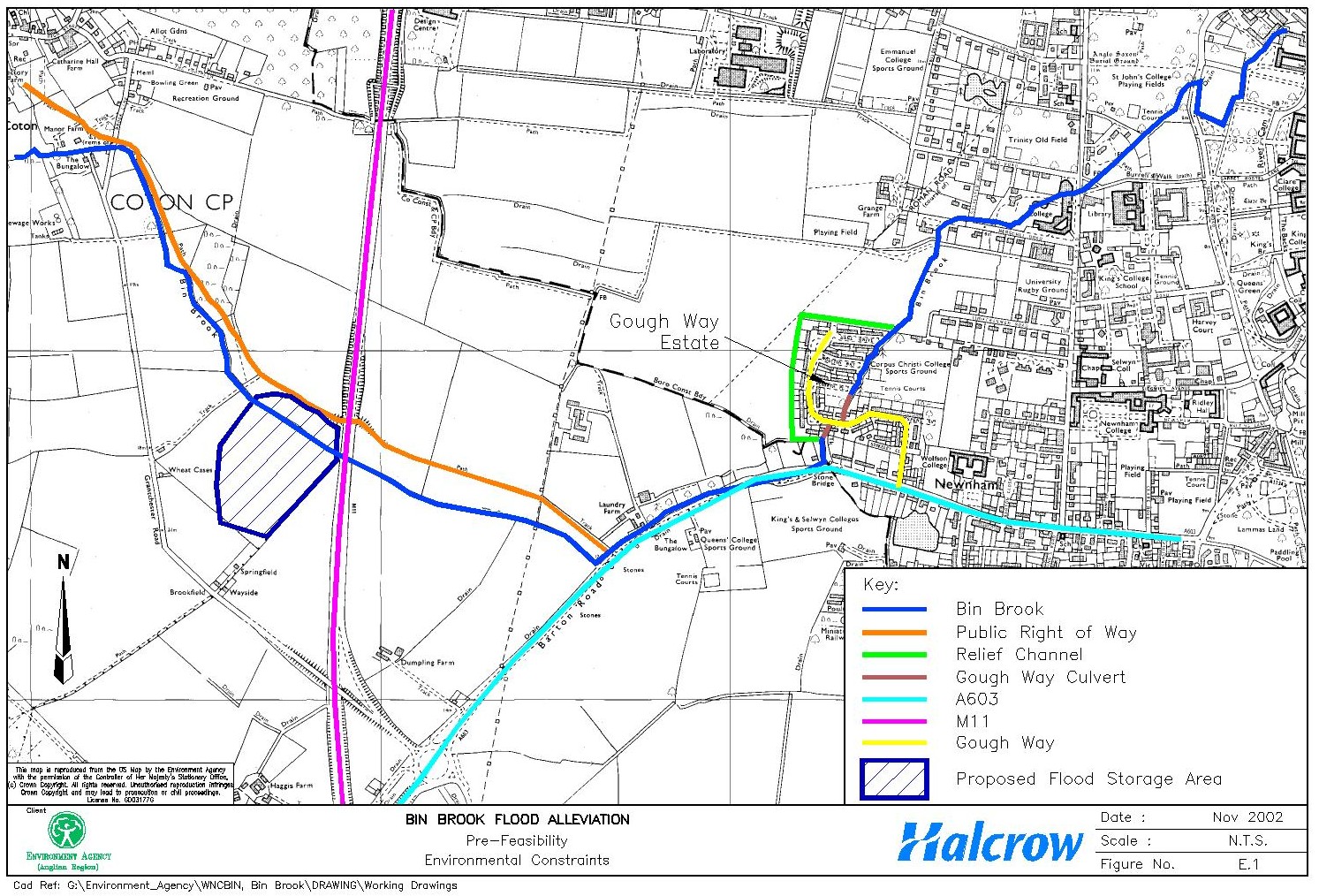
Bin Brook is a tributary of the River Cam in Cambridgeshire. It extends from Hardwick, a village to the west of Cambridge, to its confluence with the River Cam in the centre of Cambridge. Within the study area Bin Brook flows mainly through arable land. It passes underneath the M11, then runs parallel with the A603 before flowing through a culvert beneath the Gough Way housing estate in Cambridge ( Figure E.1). The brook then flows towards Clare Hall College and through the grounds of Robinson College and St John’s College in Cambridge before joining the River Cam.
The Gough Way housing estate is protected from flooding by a flood relief channel, which skirts the estate carrying excess water downstream during high flows ( Figure E.1). The relief channel is a concrete channel for the majority of its length and an earth channel for the remainder. During a recent flood event in October 2001 properties on the Gough Way estate and a number of properties adjacent to the Bin Brook immediately up and downstream of the estate were flooded, as the capacity of the flood relief channel was not sufficient to contain the volume of water flowing downstream. The Environment Agency has therefore commissioned Halcrow Group Limited to look at the various flood alleviation options for this area of Cambridge. This Screening and Scoping File Note looks at the environmental impacts of the proposed options.
The options available for flood alleviation in the study area are as follows.
Under this option no works will be undertaken on the Bin Brook, including maintenance works. However, as no work will be undertaken to clear the main channel, relief channel or the culvert or to maintain the channels, blockages may form and begin to restrict flow. Over time the condition of the channels will deteriorate and they will become permanently blocked, resulting in severe flooding of the Gough Way estate. It is likely that the properties on the Gough Way estate will eventually become uninhabitable due to continued flooding.
Under this option the existing situation will remain and maintenance will continue as at present. There will be no improvement in the level of flood protection provided to the properties on the Gough Way estate and near to the Bin Brook currently affected by flooding.
This option involves increasing the capacity of the channel in order to allow greater flows to be carried downstream. There are two sub-options within this option:
This option will involve the storage of approximately 150,000m3 of water upstream of the M11 ( Figure E.1). The land is currently arable land but the Cambridge Preservation Society, the landowner, is considering creating an artificial wetland at this site as part of undertaking a project to create Coton Countryside Park. This option will involve the construction of an earth embankment with a control structure across the channel in order to create a flood storage area. Incorporating the flood storage area into the proposals by creating a wetland area could provide mutual benefits to both the Cambridge Preservation Society and the Environment Agency in terms of cost savings, shared construction works and enhancement opportunities.
A provisional determination has been made as to the level of Environmental Impact Assessment (EIA) required, and the likely consenting regime to be followed for each of the options currently being considered (Table 1).
Table 1 – Level of EIA and Appropriate Legislation
|
Level of EIA required and consenting regime: |
Date table completed: 25/10/02 |
||||
|
Options |
|||||
|
1 |
2 |
3a |
3b |
4 |
|
|
Level of EIA Required:
|
N/A |
N/A |
2 |
2 |
1 |
|
Do the proposals benefit from permitted development rights (GPDO 1995)? |
N/A |
N/A |
Yes1 |
Yes1 |
No |
|
Are the proposals likely to require planning permission (TCPA 1990)? (subject to confirmation by local planning authority) |
N/A |
N/A |
No |
No |
Yes |
|
Are proposals likely to fall under Town and Country Planning EIA Regulations 1999 (SI 293)? |
N/A |
N/A |
No |
No |
Yes |
|
Are proposals likely to fall under the Land Drainage EIA Regulations 1999 (SI 1783)? |
N/A |
N/A |
Yes2 |
Yes2 |
Yes |
|
Are proposals likely to fall under other EIA Regulations (specify)? |
N/A |
N/A |
No |
No |
No |
|
Are proposals likely to require consents under other legislation(specify)? |
N/A |
N/A |
No |
No |
No |
The flood alleviation scheme on the Bin Brook will need to be subject to either level 1 or 2 EIA. A final Screening Decision (statutory) will need to be made once the option has been selected. Further outputs that will be required as part of the EIA for the scheme will be:
Scoping Report
Environmental Statement (Level 1) / Environmental Report (Level 2)
Environmental Action Plan
Key environmental issues, raised as a result of a desk study and consultation with Environment Agency specialists are outlined below. These issues are taken into account in the final Pre-Feasibility Report.
This option will result in considerable disruption and disturbance to residents of the Gough Way estate and properties in the immediate vicinity of the Bin Brook, as the channels and culvert deteriorate and become blocked subsequently resulting in increased flooding of the area. It is anticipated that the deterioration will result in continuous flooding and the land will revert to permanent floodplain, causing significant damage and causing the properties to become uninhabitable. This will cause major disruption to the affected residents, resulting in considerable stress.
Under this option, the residents of the Gough Way estate and nearby properties will continue to experience flooding of their properties during high flow events above a magnitude of greater than a 1 in 40 year standard.
Increasing the capacity of the flood relief channel will enable larger flows to be passed downstream, therefore alleviating the flooding of the Gough Way estate and nearby properties. Flooding will only be experienced during a flood event at a magnitude of greater than a 1 in 50 year standard.
The works to enlarge the flood relief channel will take place at the bottom of residential gardens, although it will not encroach onto residential property. This will therefore result in some disruption and disturbance during construction.
Increasing the capacity of the Gough Way culvert will allow larger flows than at present to be discharged downstream, therefore alleviating the flooding experienced by the Gough Way estate residents and those of nearby properties, during flood events. Following construction, flooding will only be experienced during flood events at a magnitude greater than a 1 in 50 year standard.
During construction, the works will result in considerable disturbance to residents of the Gough Way estate through noise, vibration and visual intrusion. The properties immediately adjacent to the works area will be particularly affected. Disturbance could be mitigated by restricting working hours to avoid certain times.
It is likely that the garden fences of the properties immediately adjacent to the works area will need to be removed in order to allow access to the culvert. Working within the gardens will be avoided where possible.
The Gough Way road itself will have to be closed during construction to allow for installation of the culvert. It is possible that only one lane will need to be closed at one time, however, considerable disruption will be caused to road users beyond the works. Cambridge City Council Highways Department will need to be contacted regarding the works to the road and the setting up of traffic control measures. As there is only one access to the estate it may be necessary for alternative access to be provided or car parking provision to be implemented if access cannot be maintained. The walkway through the estate, which runs on top of the culvert, will also have to be closed during construction, restricting access by foot.
This option will increase the level of flood protection afforded to the properties on the Gough Way estate, and those nearby. Therefore, flooding will only be experienced at events of a magnitude greater than a 1 in 50 year standard.
The proposed location of the flood storage area is adjacent to a public Right of Way ( Figure E.1). If the Right of Way is affected during construction of the flood storage area, it will be necessary to employ measures to avoid disturbance to the public using this path e.g. temporarily divert the footpath away from the works area. Temporary diversion of a public Right of Way will require permission from Cambridgeshire County Council, there will be a charge of approximately £600 for this diversion, which will take approximately 4-6 weeks to put in place. If the Right of Way is likely to be adversely affected during operation of the flood storage area, for example if it will become periodically flooded, it may be necessary to permanently divert or raise the footpath. A permanent diversion will also require permission from Cambridgeshire County Council, which can take up to six months, there will be a charge of approximately £1000 for the diversion order.
This option will affect any protected species supported by the habitats affected the flooding.
There is potential for adverse impacts upon fish within Bin Brook, as the channel becomes obstructed this may prevent migration up and down stream. The impacts on fisheries will increase as the channel becomes totally blocked and floods out of bank; areas downstream of the blockages may become dry resulting in the stranding of fish.
The eventual reversion back to the natural floodplain may have beneficial impacts upon flora and fauna due to the recreation of a natural channel when the Bin Brook finds its own natural route through the study area. The flooding may also result in the creation of wet grassland habitat from land that is currently arable upstream of the culvert as this will experience an increase in the frequency and duration of flooding.
No significant impacts upon flora and fauna are expected from this option. The study area will continue to be flooded during extreme events, however, there are no designated sites that will be affected. There may be protected species located in the habitat which is affected by flooding, however, as the probability of flooding will not change, there will be no change to the existing situation.
The relief channel is predominantly a concrete channel and is dry for the majority of the time. It is therefore unlikely that protected species such as water vole will be present. The channel does however appear to be over-grown and there are scrub and trees immediately adjacent to it. It is possible, therefore, that protected species may be present, e.g. badgers. It is therefore recommended that a walkover survey is undertaken to assess the presence or absence of protected species.
Should the works require removal of vegetation, this should be undertaken outside of the bird-breeding season to avoid disturbance of breeding birds. If mature trees have potential as bat roosts they should only be removed during either March/April of October/November.
The existing channel of the Bin Brook will be de-watered during construction. There is therefore the possibility that fish may become stranded in the dry channel, particularly in the natural channel downstream of the culvert. Stranded fish should be translocated by a fisheries expert.
There are no designated sites within either the study area or the area affected by the proposed flood storage area. There is the possibility that protected species, e.g. water vole (Arvicola terrestris), may be present on the Bin Brook. A survey should therefore be undertaken to assess the presence or absence of this species and any other protected species in the proposed flood storage area.
If vegetation needs to be removed during the construction of the flood storage area, there may be impacts upon breeding birds depending upon the time of year. Vegetation removal should therefore be undertaken prior to the beginning of March or after August to avoid the bird-breeding season. Mature trees, which are to be removed, should be inspected to whether they form bat roosts. If they have potential as bat roosts they should only be removed during either March/April of October/November.
The construction of a culvert to carry flows through the flood storage embankment will require a short diversion channel to be constructed during construction. Fish may become stranded when the existing channel is de-watered and so these will need to be translocated by a fisheries expert. The same situation will arise when the brook is returned to its existing route.
The incorporation of a flood storage area into the Coton Countryside Park Project will provide an area of wetland. This could form habitat for a variety of flora and fauna, and will be an ecological benefit.
No impacts upon air or climate are anticipated from any of the options.
This option will result in the flooding of properties on the Gough Way estate, which will eventually become uninhabitable and have to be abandoned. The flood damage to the properties will have considerable visual impact upon the surrounding area.
This option could also potentially have beneficial impacts due to the Bin brook reverting back to a natural channel forming a natural landscape through the study area.
The "Maintain" Option will not result in any change to the landscape or visual amenity of the area.
It is not anticipated that there will be a significant long-term visual impact from works to increase the capacity of the relief channel.
It is not anticipated that there will be a significant long-term visual impact from the works to increase the capacity of the Gough Way culvert.
The embankment forming the flood storage area will be an unnatural feature in the landscape, particularly as it is proposed to use the local area as a Countryside Park. This impact could be minimised through sensitive design and an appropriate landscaping scheme.
This option will have considerable impact upon the hydraulics of the channels as they deteriorate, eventually resulting in continual flooding of the Gough Way estate.
There may be impacts upon the water quality of Bin Brook from both the deterioration of the channels and culvert and from the flooding of properties.
The increased flooding of the area resulting from this option may cause a deterioration in the water quality of the Bin Brook and the River Cam due to floodwaters becoming contaminated from sewers and drains.
This option will result in the water regime remaining as at present, therefore no impacts are anticipated.
The works to increase the capacity of the relief channel should not result in significant impact. The channel is dry for the majority of the time and, therefore, providing the channel remains dry during construction, no water quality issues should arise. Long-term hydrology issues should also not arise, as there will be no change to existing flows except during extreme events, when the channel will carry an increased volume of water.
Should an extreme event occur during construction, provisions will have to be put in place to ensure the duration or intensity of flooding is not increased as a result of the construction works.
The works to increase the capacity of the Gough Way culvert may increase the severity of flooding if a flood event should occur during construction, as flows will not be able to pass though the culvert, only along the relief channel. Therefore, the volume of water that could be passed downstream will be reduced resulting in overtopping of the banks and therefore a greater level of flooding to the existing situation.
In-channel works may result in pollution incidents arising from increased suspended sediments. Therefore, appropriate pollution prevention guidance should be followed.
The construction of an embankment across a channel and the culvert to carry flows will require temporary diversion of Bin Brook. Changing the brook to flow through the diversion channel and then through the culvert during operation may have impacts upon the hydraulics of the brook.
In-channel works may result in pollution incidents arising from increased suspended sediments. Therefore, appropriate pollution prevention guidance should be followed.
This option will result in the residential area and the adjacent agricultural land being flooded following deterioration of the channels and culvert. The flooding will result in these areas no longer being appropriate for these land uses.
There will be no alteration to the land use.
Increasing the capacity of the relief channel by widening it will require some land take. This will be confined to the lengths where there is no concrete channel and the land used is likely to be the arable land which bounds one side of the channel. The amount of land lost is likely to be relatively insignificant, however, compensation to the landowner will still be required.
The works to increase the capacity of the Gough Way culvert will not change the land use of the study area. The gardens immediately adjacent to the culvert works may be affected temporarily during construction, but disturbance will be minimised as far as possible.
The construction of a flood storage area will result in the loss of an area of arable land. This is not anticipated to be significant because the Cambridge Preservation Society, who own the land, intend to turn the area into the Coton Countryside Park. If the flood storage area can be incorporated into the proposals for the Countryside Park, the impacts upon land use will not be significant and the level of compensation to the landowner could be reduced or eliminated.
This option may result in the damage of archaeological finds and features due to the extended flooding resulting from the deterioration of the culvert and channels. It is known that there was a considerable Roman presence in the area therefore there is high potential for finds in the area. The Roman Road to the north may also be affected by the extensive flooding.
This option will not result in any impacts upon features of archaeological or cultural importance. The buildings which were affected by the flooding, and those which will continue to be affected, are not of historical importance; the college buildings which were affected by the flooding are all modern.
Due to the potential for archaeological finds in the study area, it is possible that the works will result in damage or disturbance to features. It may be recommended that archaeological investigation is undertaken prior to the works, or alternatively, a watching brief may be required during construction.
It is not anticipated that there will be archaeological impacts from works to the Gough Way culvert as any finds will have been previously disturbed by construction of the original culvert.
Consultation with Cambridgeshire County Council Archaeology department has indicated that there has been considerable Roman activity in the study area. Excavation works may result in damage or disturbance to archaeological features. It is therefore possible that archaeological investigation may be required. This may take the form a formal archaeological investigation or a watching brief during excavation works.
This option will result in the flooding of the Gough Way road, preventing access to the Gough Way estate.
This option will not have an impact upon traffic or transport.
The works to increase the capacity of the relief channel will result in an increase in traffic in the works area, due to the importation of materials and the removal of excavated waste material. As access to the site will be required via residential roads, restrictions on hours of delivery could be imposed to reduce impacts.
The works to increase the capacity of the Gough Way culvert will cause significant disruption to traffic on the estate as during works to the culvert the road will need to be closed, although it is possible that one lane may remain open at a time. Consultation will have to be undertaken with Cambridge City Council Highways Department regarding road closure and traffic control measures. If works require the full closure of the road, arrangement will have to be put in place to allow residents to access their properties.
The works will also result in an increase in traffic in the estate due to the number of construction vehicles, the importation of materials and removal of waste.
The construction of a flood storage area will result in an increase in the volume of traffic during works, but, because the embankment will be constructed from material won on site, providing it is suitable, this will not be significant.
The increased flooding of the area resulting from this option may cause pollution of the soils and groundwater of the area due to floodwaters becoming contaminated from sewers and drains.
This option will not result in significant changes to the existing soils, geology or hydrogeology of the study area.
It is not anticipated that increasing the capacity of the relief channel will result in significant impacts upon the soil, geology or hydrogeology of the area. The majority of the land that will be used is agricultural land, and so it is not anticipated there will be issues associated with land contamination or the disposal of waste material.
It is not anticipated that the works will have a significant impact upon the soil, geology or hydrogeology of the area.
It is not anticipated that a flood storage area will result in significant impacts upon the soil, geology or hydrogeology of the area. The site is agricultural land and it is not anticipated that there will be issues associated with land contamination or the disposal of waste material. It is recommended, however, that a desk study is carried out to check for potential contamination and gravel layers or groundwater aquifers.
There are no anticipated key impacts upon the use of natural resources from any of the proposed options. Using recycled material in construction and re-using excavated material on site as part of Options 3a, 3b and 4 could reduce the impact upon natural resources.
The are no additional impact anticipated from Options 1, 2, 3a, 3b or 4.
Consultation should continue throughout the feasibility stage of the flood alleviation scheme with the following key consultees:
Environment Agency EIA Officer
Environment Agency Conservation Officer
Environment Agency Biology
Environment Agency Environmental Protection
Environment Agency Fisheries Officer
Environment Agency Water Resources
English Nature
English Heritage
Countryside Agency
Cambridgeshire County Council Archaeology Department
Cambridgeshire County Council Highways Department
Cambridgeshire County Council Rights of Way Department
South Cambridgeshire District Council
Cambridge District Council
Cambridgeshire Wildlife Trust
RSPB
Cambridgeshire Preservation Society
Landowners
Residents of the Gough Way estate
Those consultees that have already been contacted at pre-feasibility stage are highlighted in italics. The Agency EIA Officer also contacted various members of the Fisheries, Recreation and Biodiversity Department regarding any concerns.
1 Under the Town and Country Planning (General Permitted Development) Order 1995 Schedule 2 Part 15 Class A(b)
2 Subject to further assessment
Doc
No Rev: Date: October 2002